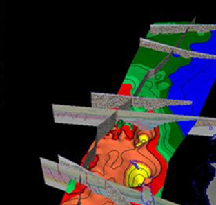
Petroleum systems models are 1D, 2D, or 3D large-scale geologic models. These models cover areas ranging from a single charge area for a prospect to regional studies of entire basins and resource assessments at a megaregional scale covering multiple basins. The models provide a complete record of the evolution of a petroleum system, including pressure and temperature history. A petroleum systems model provides the only means to integrate all physical aspects (source, trap, seal, and reservoir) and time (charge) to quantify and analyze processes and reduce exploration risk. Models can be built in the Petrel E&P software platform, which provides full integration with critical input data such as seismic and well data, the structural framework, and PetroMod software’s stand-alone builders. Models could also be built in PetroMod software directly.
Model geometry
- Dynamic: changes during simulation based on deposition and compaction (backstripping) including geological processes such as erosion or salt diapirism (not available in the Petrel platform yet).
- Structural restoration: explicit definition of the changing structure through geological time via a special mode (TecLink) for complex extensional and compressional tectonic environments with overthrusted layers and faulted geometries.
- Layers: sequence of geological layers, deposited during a given stratigraphical event and subdivided into regions of similar facies.
- Facies: specification of the lithological rock type and the organic facies, including evolution of permeability, compaction parameters, heat capacities, thermal conductivities, and geomechanical properties during geological time.
- Boundary conditions: changing paleo water depth, heat flow, and sediment/water interface temperature during the geological history.
- Local grid refinement: for areas of interest or in specific stratigraphic units.
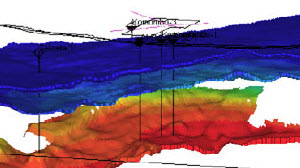
Model scale
- From about 10 km × 10 km to more than 1,000 km × 1,000 km and down to a depth of 100 km.
- Entire geologic history of a basin on geologic timescale.
- Complete stratigraphy in the user’s definition of resolution (more than 100 layers).
- Local grid refinement for locally refined, high-resolution models within a larger PetroMod software model (e.g., a higher-resolution prospect area within an existing regional 3D PetroMod software charge model).