Analog to digital: Field geology and collaboration through the lens of a simple geologist and a 4K drone
As a young student I was searching for a direction, a new branch that would make sense. A couple of branches were already broken; art—couldn’t get in, mathematics—didn’t have the brain. Geology came as a surprising option; dinosaurs, cool rocks—tectonics—what’s not to like! Still, when a master was up for grabs I was not sure, I had no strong preference as many of my co-students seemed to have. Then one professor came along and asked if I would like to do a thesis on structural geology in the fjords of East-Greenland—great analog outcrops—hell yeah! All the fog cleared; how can you turn down two full two-month field seasons on the most beautiful spot on earth?
I believe this was one of these life-changing moments that steered me into field work. My first job was in Iran as a wireline field engineer, working the deserts and basins in the foothills of the fantastic Zagros mountains. However, after a few years, I found myself in the Schlumberger software business. As many others I saw only laptop screens and nice 3D models, so I would use any opportunity to get onto any field course possible, but it was never that easy to get the time, funding, or the permission.
In 2011, good colleagues in oil and gas companies asked if a couple of us from the service companies would join a field trip organized by them as part of a license round. Some early thought leadership was initiated by those companies to see if synergies and discussion between geoscientists in the oil and gas and service companies could lead to different views, new insight, better software, etc. Utah was the perfect analog playground; Dr Haakon Fossen the perfect guy to reveal the mystery of relay ramps and deformation bands.
From day one my field experience was still the same; lots of knowledgeable people, professors, experienced geologists, some rock samples, a few drawings, field logs and tons of photographs—all made perfect sense there and then….but never again used apart from the top 10 Insta-friendly location images and a few sample analysis making into ‘the report’. The ‘analog’ data just disappeared.
In 2016, a large Norwegian E&P company engaged with Schlumberger to get a better understanding of reservoir rocks in the Barents Sea through an ongoing R&D project on the arctic archipelago of Svalbard. It took me five minutes to get a go from my manager—and five days to get the risk assessment through the system.
Finally back in the arctic looking at amazing field analog again it spurred the idea of a different approach to the traditional field work ‘hit and run’ field trips, with fast boats and drones; why not let a bunch of geoscientists or software engineers get out in the field, collect a lot of data, cover a large area with drones and build digital outcrops models from auto interpreted images, then store them digitally for use in exploration or reservoir characterization as searchable and accessible analog data? Or even use them directly in virtual training or to plan the next field trip.
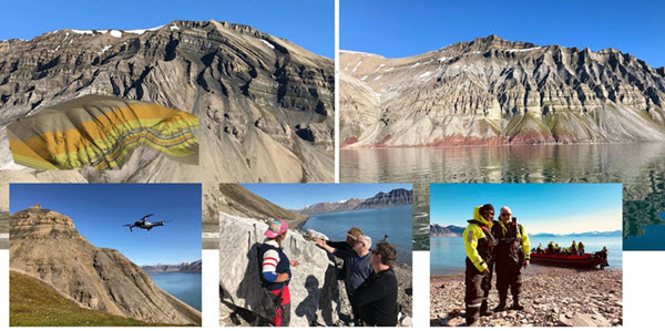
Half the ‘digital’ work was already done by a good friend and his colleagues, handling the drone, getting drone images refenced and putting it into the Petrel E&P software platform, texturizing and applying novel prototypes from existing ant-tracking technology to auto-interpreting faults, fractures and bedding. To close the loop all these data needed to be stored, accessible and searchable; hence contextualized for its next mission. Suddenly the data is ‘digital’ and not just left in a drawer or in a cupboard collecting dust.
Many of these ideas are of course not new; drones and digital outcrops models are almost commodity these days; however, consuming and using them in day-to-day work, stored digitally in a data ecosystem, searchable and acting as a contextual knowledgebase, is probably still in its infancy.
Whatever the digital world is bringing, it can never replace the field geology itself, but it can hopefully help teams to retain the knowledge, get insight into new exploration targets, and plan the next field trip in a more targeted and lean way—using drones to cover large areas as well as getting a lot of people out of their chairs and into the field. I still hope oil and gas and service companies can go to the cold arctic or warm desert to discuss ideas in a collaborative way, collect great images and insight using drones and clever auto-interpretation tools,
The beauty of geology is still out there in the field—the analogs—and we can now make more use of them for years to come in their transformed and digital format.
Author information: Tormod is the tall Norwegian geologist that finds himself stuck between Arctic field work, 3D modeling and digital transformation.
With a structural geologist background he has worked with field geology and software training and software development for most of his 20 year career—apart from his few years in wireline, where he had to touch mechanical, electrical, radioactive, and explosive stuff…